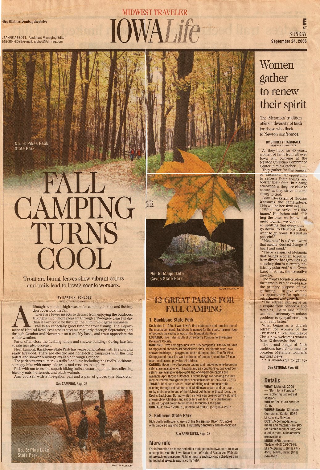
by Cassie, September 10th, 2011 | No Comments
We went on an amazing four day tour of southwest Bolivia! We traveled through an incredible variety of scenery. We started in Tupiza, which has landscapes similar to the southwest of the US.

El Sillar outside Tupiza
On the second day of the tour, we began entering the salt flats. However, the first salt flat consisted of borax, not salt. The borax was being harvested for export to Chile where they use it for manufacturing porcelein.

Laguna Hedienda, which means lake that smells because of the sulfur

Laguna Verde and Volcan Licanabur
Laguna Verde is the beautiful green color due to the minerals in the water. However, the water is toxic, so you cannot drink it. Volcan Lincanbur is one of the highest mountains in Bolivia at 5,890 meters.

Geysers at almost 5,000 meters
These geysers are part of a volcanic system, and the smell of sulfur pervades the air around the geysers. Some of the geysers are pools of bubbling mud, and it is mesmerizing to watch, similar to a lava lamp.

Laguna Colorada with lots of flamingos
Laguna Colorada is a red color due to the algae in the water. The lake is full of flamingos! Normally, you associate flamingos with warm, tropical climates, but these are high altitude flamingos that are adapted to the cold weather. When we drove by Laguna Colorada the next morning, it was partially iced over!

Arbol de Piedra: Tree of Stone
The Arbol de Pierdra is next to a bunch of volcanic rocks. The Arbol de Piedra has eroded so much at the bottom that it is amazing that it is still standing. We got to climb on the other rocks, but it was not allowed to climb on the Arbol de Piedra. 🙂

Lake with lots of flamingos!

High altitude flamingos!
On the third day of the tour, we stopped at a few lakes, and each one of them had lots of flamingos!
On the final day of the tour, we got up early to watch the sunrise over the Salar de Uyuni from the Isla Incahuasi. The sunrise was beautiful, and the salt flats seemed like a big white sea.

Sunrise at Isla Incahuasi

Gigantic cactus at Isla Incahuasi
Isla Incahuasi used to be a coral reef in the ancient sea that covered the Salar de Uyuni. Now, it is covered in gigantic cacti. The current largest cactus is 9 meters tall, and it is 900 years old. The previous largest cactus died in 2007, and it was 12 meters tall and over 1200 years old!

Crazy photos on the Salar de Uyuni
With the white of the Salar de Uyuni, you can take crazy photos where the perspective is totally unreal! We had an amazing time our our tour of southwest Bolivia! Check out the rest of the photos!
by Cassie, August 31st, 2011 | No Comments
This time, we went on a different trek that starts in the high mountains and goes down into the tropical Yungas mountains. The trek was a lot of fun, but it was tough. Plus, the weather didn´t cooperate with us very much. We spent the first day hiking through the amazing Palca Canyon with 100 meter high walls. However, the canyon walls were not made of stone, instead they were made of mud. We could see places where huge chunks of mud had fallen down.

Palca Canyon
The next day we went over a pass of 4,670 meters, and the weather turned as we went over the pass. It became very cold and a wind was blowing clouds over the pass. When we got to the pass, we couldn´t see anything after all the hard work of climbing the pass!

Start of Takesi trek

Hiking up to the pass on old Inca trail

At the pass
The next day, the weather cleared up in the morning, but it clouded in later in the morning. For a while, we were hiking in the clouds, but finally, we hiked below the clouds and had views of the mountains again. We spent our third night camped next to a river. We were supposed to cross a suspension bridge, but it had been destroyed. Instead, we had to cross a unstable, makeshift log bridge.

Hiking down the valley on the old Inca Trail

Crossing the river along this makeshift log bridge
The final day, we continued hiking down into the Yungas moutains. Part of the trail had been destroyed by a landslide, so we had to go on a detour. We also were supposed to go on another detour around an unstable concrete bridge, but we missed the detour and crossed the bridge anyway. The bridge was really scary with no guardrails, and the concrete slabs rocked as you walked across them. Below the bridge was a steep mountainside, so it definitely got your heart pumping to get across. But, we made it across safely.

Hiking through the jungle

Yungas mountains

Crossing scary concrete bridge
Then, we had an adventure getting back to La Paz from the end of the trek. We went to the mining town of Chollja, but the next bus didn´t leave until 5am the next morning. The town didn´t have good prospects for a clean hostal to stay the night, so we continued hiking to the nicer town of Yanacachi. We spent the night in Yanacachi in basic, clean accomodations, and we arrived at the place to get the micro back to La Paz at 4:30am. However, the road was blocked due to some workers striking, so it seemed that we might not be able to get back to La Paz from Yanacachi. So, we began hiking down to the main road past the road blockage where we could catch a bus going back to La Paz. As we were hiking, the micro going from Yanacachi to La Paz came by. The driver was planning to try to get through the blockade, so we hopped in for the ride. We arrived at the road blockage, and somehow, the driver convinced the striking workers to let us through. First, the strikers had to look into the micro to make sure we were okay. Apparently, we didn´t look too suspicious because we were let through the road blockage, and we made it back to La Paz!
by Cassie, June 24th, 2011 | 4 Comments
We were talking with the Iowa Outdoor Unlimited group about places to hike and camp while backpacking at Yellow River State Forest. While sharing our favorite places with the group, we thought it would be great idea to compile a list of the best places to hike and camp in Iowa to share with others. If you have other places you like to hike or camp in Iowa, add a comment!
Hiking
Prairies
1. Chachaqua Bottoms Greenbelt
Chachaqua Bottoms Greenbelt is part of the Polk County park system. It is northeast of Des Moines past Bondurant on Hwy 65, and it is only about a half hour drive from Des Moines. There is a small campground, and a set of trails by the South Skunk River. My favorite place in the park is a small prairie at the Sand Hill Unit on NE 118th St. One year, I was hiking through the prairie, and the prairie grasses were over 10 feet high. As I walked along the mowed path, I could not see anything but the tall grasses on either side. The experience put me in the shoes of the pioneers that first came to Iowa and all they saw was an endless landscape of prairie.

2. Jacob Krumm Nature Preserve
Krumm is a nature preserve close to I-80 right before you reach Grinnell. There are 5.25 miles of trails with two loops. One loop goes around a reconstructed prairie, and a second loop goes around a dammed lake. The loops are connected with a short trail. The prairie is especially beautiful when the flowers are in bloom.

3. Neal Smith Wildlife Refuge
Neal Smith is the largest reconstruction of tall grass prairie in the US with over 5,000 acres of prairie. The size of the prairie is amazing. It is also a wildlife refuge, and if you’re lucky, you’ll see bison and elk. I was fortunate to see the herd of bison up close right next to the fence by the road. There are five miles of trails. In addition to the Tallgrass Trail by the Prairie Learning Center, I also recommend the Savanna Trail. The Savanna Trail goes through an ancient forest of burr oak trees. Neal Smith is near Prairie City, and it is about 40 minutes from Des Moines.

Bison at Neal Smith

Burr Oak Trees on Savanna Trail
Des Moines Area
1. Brown’s Woods
Brown’s Woods is part of the Polk County park system. It offers two miles of trails. It is the nicest hike in the woods in the Des Moines area.
2. Walnut Woods State Park
Walnut Woods has 2.5 miles of trails. The trails wind along the Raccoon River and through the woods. There is also an area where they feed the birds, and they have a bird blind where you watch the birds as they feed. It is also a great place to have a picnic.

3. Raccoon River Park
Raccoon River Park is part of the West Des Moines park system. It has a 3.2 mile trail that loops the lake and also goes along the Raccoon River.
4. Gray’s Lake Park
Gray’s Lake is part of the Des Moines park system. It has 1.9 mile trail around the lake. Since the trail is all paved, it is not really hiking, but it is a fun walk. It is especially nice to walk around the lake at night with the bridge lit up and the Des Moines skyline as the backdrop. There are also lots of activities going on at the lake, and you can rent paddle boats, canoes, kayaks, and sailboats at the lake. During May through September, they do Full Moon Floats on the lake where you can rent a boat and paddle around the lake under the moonlight.
5. Waterworks Park
You can hike along an “unofficial” trail that follows the river to the left after the footbridge over the Des Moines River. It used to be better marked, but with the recent flooding, it is harder to find your way. But, it is good place to make your own trail and explore the woods along the river. There are also bridle trails that you can hike along. Another option is to hike along the Bill Riley bike trail, and when you get to the railroad bridge, cross the railroad bridge to hike along the mountain bike trails. Also, if you want to feed the horses along the Bill Riley bike trail, brings some carrots. 🙂
6. Lake Ahquabi State Park
Lake Ahquabi has nice wooded, hilly five mile trail around the lake. Lake Ahquabi is south of Indianola.
Other Hikes
The Hiking Iowa Falcon Guide has a lot of great hikes in it. Hikes I recommend are:
#7 Mines of Spain Recreation Area
This is a neat hike near Dubuque by the Mississippi River.

#22 Lacey-Keosaqua State Park
I grew up near this state park, and it has a lovely hike around the lake. It has lovely stone bridges along the trail that were build by the CCC.
Camping
Central Iowa
All of the these campgrounds (except Pine Lake) are within an hour’s drive of Des Moines.
1. Ledges State Park
When hiking in Ledges, you do not feel like you are in Iowa. The amazing sandstone cliffs are unusual and unique in Iowa. While at Ledges, I recommend putting on your sandals and creek-stomping to see the cliffs up close. The hike to Lost Lake has a great overlook of the Des Moines River.
The campground at Ledges has hike-in campsites, and they are only a short hike from the parking lot. If possible, I recommend camping at the hike-in sites for a more secluded campsite. Ledges is near Boone, and it is about an hour drive from Des Moines.

Sandstone cliffs

Overlook of Des Moines River
2. Pine Lake State Park
Pine Lake has over 10 miles of trails. The campground is next to the upper lake, and there is a trail from the campground that goes to the lower lake and loops around the lake. The pines trees on lower lake loop are 250 years old. There is another trail that goes along the Iowa River. Pine Lake also has cabins that open year round, and it is a great place to rent a cabin during the winter.
Pine Lake is near Eldora, and it is about an hour and a half drive from Des Moines.


Pine Lake Cabin
3. Rock Creek State Park
Rock Creek is near Grinnell, and it is about an hour drive from Des Moines. The state park is at a dammed lake. The campground is huge with 200 campsites. Rock Creek is a great place to camp during the summer because: 1) You are guaranteed to get a campsite without a reservation even on the nicest weekend 2) The area for tents is in a spacious area away from the RVs. The park has lots of trails around the lake. Also, Rock Creek is nearby Jacob Krumm Nature Preserve, so you can also go hiking there.

4. Elk Rock State Park
Elk Rock State Park is on Lake Red Rock near Pella, and it is about an hour drive from Des Moines. There is a separate loop in the campground for tents, so you can be separate from the RVs. The park has 13 miles of trails. Elk Rock also has an equestrian campground, so you’re likely to run into horseback riders on the trails. A side trip from Elk Rock is Cordova Park. Cordova Park has a 106 foot observation tower with great views of the lake and surrounding area. Make sure you have change when you visit Cordova Park because it is 50 cents to go up in the tower, and you must have exact change.

Camping at Lake Red Rock

Cordova Park Tower
5. Pammel Park
Pammel Park is in Madison County near Winterset, and it is about a 50 minute drive from Des Moines. The campground is smaller with only 36 campsites. They also have yurt cabins available to rent. There are only 5 miles of trails at the park, but it has a neat backbone ridge that is similar to the rock formations seen at Backbone State Park. The park is next to the Middle River, and for a little excitement, drive across the Middle River Ford.

Pammel Park Backbone

Driving across Middle River Ford
Eastern Iowa
1. Yellow River State Forest
Yellow River is in the northeast corner of Iowa, so it is a long drive of over four hours to get there from Des Moines. Yellow River is the best place to go backpacking in Iowa. There are over 25 miles of trails, and there are four backcountry campsites. The terrain is hilly, so it is good place to get in shape for a backpacking trip in the mountains.

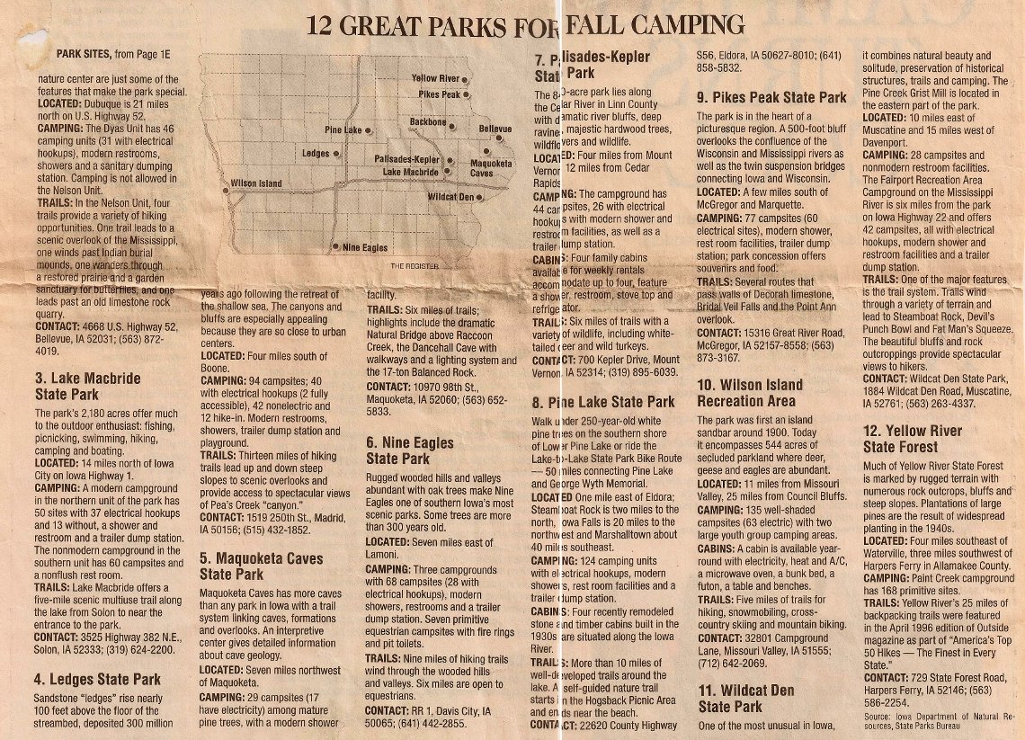
2. Pikes Peak State Park
Pikes Peaks is also in the northeast corner of Iowa, and it is a long drive of over four hours from Des Moines. Pikes Peak and Yellow River State Forest are right next to each other. Pikes Peak is on the Mississippi River, and it has impressive 500 foot bluffs. There is an amazing view of the Mississippi River from the park. The park has 10 miles of trails. The MacGregor family protected the forest in the park from logging, so the trails go through old growth forest. The park also has some Indian mounds, and Effigy Mounds National Monument is nearby. The nearby town of MacGregor is also neat to walk through with its preserved historic buildings.

3. Backbone State Park
Backbone was Iowa’s first state park, and it is one of the most popular state parks. Backbone is named for its narrow and steep ridge of bedrock carved by a loop of the Maquoketa River. Backbone is a great park for hiking, and it has 21 miles of trails. Since Backbone is a popular park, it is recommended to reserve a campsite before camping. Backbone is a three hour drive from Des Moines.

Looking down at Maquoketa River from Backbone ridge
4. Maquoketa Caves State Park
Maquoketa Caves has hilly and rocky terrain similar to Backbone, and true to its name, there are a series of caves at the park. Most of the caves require spelunking to explore, but the Dancehall Cave is so large that the hiking trail goes through it. There is also a natural rock bridge next to the Dancehall Cave. Right now, the caves are closed to help slow a disease known as white-nose syndrome that is killing bats across the eastern half of the United States. Maquoketa Caves is a 3 1/2 hour drive from Des Moines. Maquoketa Caves is a popular park for camping, and when we went, we didn’t have a reservation and found the campground was full. Luckily, we found a primitive camping area nearby at Joinerville County Park. The campground is in a small area between a road and river, so watch out for people driving by late at night. Maquoketa Caves is especially beautiful in the fall.

Natural Stone Bridge

Campground at Joinerville County Park
Western Iowa
Loess Hills: Preparation Canyon State Park
The Loess Hills are my favorite camping spot in Iowa. It’s the closest you will get to mountains in Iowa. The hills rise dramatically 200 feet above the flat Missouri River Valley. The Loess Hills are a unique geological formation that is only present in one other place in the world, the Yellow River in China. The Loess Hills are formed of a fine, light silt, and the hills have unique stair step terraces that form on the sides of the hills. The Loess Hills are about 2 hours and 45 minutes from Des Moines.
We usually camp at the hike-in campsites at the primitive campground at Preparation Canyon State Park. There is no water available at the trailhead, so make sure to bring enough water or a water purifier to get water from the creek. Preparation Canyon has lots of trails through the hills. In addition to the trails at Preparation Canyon, there is another great hike in Loess Hills State Forest by the Loess Hills Overlook Platform. From the overlook, you can hike along the ridges of the hills (Hike #38 in Hiking Iowa Falcon Guide). Another great hike near Pisgah is the Murray Hill Scenic Overlook.

View from Murray Hill Overlook
The last time we went to Loess Hills, we went to the Loess Hills Wildlife Management Area- Sylvan Runkel State Preserve, which is the location of the Loess Hills Prairie Seminar. We tried to follow the hike #37 in the Hiking Iowa Falcon Guide, but we had trouble finding the trail. Luckily, we ran into a couple who worked for the DNR, and they showed us this amazing unmarked trail that follows a high ridge in the hills. Primitive camping is allowed in the Loess Hills Wildlife Management Area, so we hiked up the ridge and camped on top of the ridge. To get to the “unofficial” trail, follow the directions to the Oak Avenue/178th Street parking area in the Hiking Iowa book. Drive west along 178th Street from the parking area and park at another parking area on the right. Here is a map. From the parking area, start hiking towards the ridge. You’ll hike by a field, and then you should see a faint trail that climbs up the ridge.

Hiking along the ridge at Sylvan Runkel

“Cat step” terraces on the side of the hills
Recommended parks I have not visited:
1. Palisades-Kepler State Park
“The 80 acre park lies along the Cedar River in Linn County with dramatic river bluffs, deep ravines, majestic hardwood trees, wildflowers, and wildlife.”
Six miles of hiking trails.
Located 12 miles from Cedar Rapids.
2. Bellevue State Park
“High bluffs with scenic views of the Mississippi River, 770 acres with timbered walking trails, a butterfly sanctuary, and an enclosed nature center are just some of the features that make this park special.”
1.85 mile trail in the Nelson Unit, and 3.9 miles out and back on trail in the Dyas Unit.
Located 21 miles south of Dubuque.
3. Wildcat Den State Park
“One of the most unusual in Iowa, it combines natural beauty and solitude, preservation of historical structures, trails, and camping.”
4.5 miles of trails along beautiful bluffs and rock outcroppings.
Located 10 miles east of Muscatine and 15 miles west of Davenport.
4. Wilson Island State Park
“The park was first an island sandbar in 1900. Today it encompasses 544 acres of secluded parkland where deer, geese, and eagles are abundant.” Five miles of hiking trails.
Located 11 miles from Missouri Valley and 25 miles from Council Bluffs.
Des Moines Register article on recommended parks:
Page One
Page Two


