We had a lot of fun biking down the World´s Most Dangerous Road! The road got its title because about 300 people per year died driving along the road, and as a result, they built a newer road between La Paz and Coroico to prevent road deaths. It would definitely be scary to drive along the road, but it is a lot of fun to ride down the road on the bike. There are sharp curves with steep cliffs on the edge of the road. The scenery is beautiful starting in the snow covered mountains and descending 3,500 meters to end in the jungle. Since the new road has been constructed, there is barely any traffic on the old road, so it was safe to ride down on a bike. In fact, most of the traffic on the road now is tourists riding bikes. We only encountered two vehicles while we were riding down the road. We ended the ride in Coroico, and we spent a day relaxing at a lovely campsite there.
Starting the bike ride in the high mountains
World´s Most Dangerous Road winding its way down the mountains
Our taxi from Yolosa to Coroico broke down right before we got to town. The car made a horrible noise and stopped running, and then, it wouldn´t start again. It wasn´t too big of a deal, and we just hiked the remaining way to Coroico.
Relaxing at our lovely campsite in Coroico with WiFi!
This time, we went on a different trek that starts in the high mountains and goes down into the tropical Yungas mountains. The trek was a lot of fun, but it was tough. Plus, the weather didn´t cooperate with us very much. We spent the first day hiking through the amazing Palca Canyon with 100 meter high walls. However, the canyon walls were not made of stone, instead they were made of mud. We could see places where huge chunks of mud had fallen down.
Palca Canyon
The next day we went over a pass of 4,670 meters, and the weather turned as we went over the pass. It became very cold and a wind was blowing clouds over the pass. When we got to the pass, we couldn´t see anything after all the hard work of climbing the pass!
Start of Takesi trek
Hiking up to the pass on old Inca trail
At the pass
The next day, the weather cleared up in the morning, but it clouded in later in the morning. For a while, we were hiking in the clouds, but finally, we hiked below the clouds and had views of the mountains again. We spent our third night camped next to a river. We were supposed to cross a suspension bridge, but it had been destroyed. Instead, we had to cross a unstable, makeshift log bridge.
Hiking down the valley on the old Inca Trail
Crossing the river along this makeshift log bridge
The final day, we continued hiking down into the Yungas moutains. Part of the trail had been destroyed by a landslide, so we had to go on a detour. We also were supposed to go on another detour around an unstable concrete bridge, but we missed the detour and crossed the bridge anyway. The bridge was really scary with no guardrails, and the concrete slabs rocked as you walked across them. Below the bridge was a steep mountainside, so it definitely got your heart pumping to get across. But, we made it across safely.
Hiking through the jungle
Yungas mountains
Crossing scary concrete bridge
Then, we had an adventure getting back to La Paz from the end of the trek. We went to the mining town of Chollja, but the next bus didn´t leave until 5am the next morning. The town didn´t have good prospects for a clean hostal to stay the night, so we continued hiking to the nicer town of Yanacachi. We spent the night in Yanacachi in basic, clean accomodations, and we arrived at the place to get the micro back to La Paz at 4:30am. However, the road was blocked due to some workers striking, so it seemed that we might not be able to get back to La Paz from Yanacachi. So, we began hiking down to the main road past the road blockage where we could catch a bus going back to La Paz. As we were hiking, the micro going from Yanacachi to La Paz came by. The driver was planning to try to get through the blockade, so we hopped in for the ride. We arrived at the road blockage, and somehow, the driver convinced the striking workers to let us through. First, the strikers had to look into the micro to make sure we were okay. Apparently, we didn´t look too suspicious because we were let through the road blockage, and we made it back to La Paz!
We had so much fun last time we were in Bolivia that we decided to come back again this summer! Because of the road blockages due to the border conflict between Oruro and Potosi, we didn´t make it to the salt flats last summer. So, we had a reason to return!
View of La Paz from the airplane
Calle Linares- right outside our hotel
Mt. Illimani
Plaza San Francisco
Last summer, Plaza San Francisco was under construction, and now it is all done. It is really nice now with steps to sit on to munch on the snacks we bought on the plaza. We also played with some kids who came up to us asking what our hand sanitizer was. 🙂
We were talking with the Iowa Outdoor Unlimited group about places to hike and camp while backpacking at Yellow River State Forest. While sharing our favorite places with the group, we thought it would be great idea to compile a list of the best places to hike and camp in Iowa to share with others. If you have other places you like to hike or camp in Iowa, add a comment!
Chachaqua Bottoms Greenbelt is part of the Polk County park system. It is northeast of Des Moines past Bondurant on Hwy 65, and it is only about a half hour drive from Des Moines. There is a small campground, and a set of trails by the South Skunk River. My favorite place in the park is a small prairie at the Sand Hill Unit on NE 118th St. One year, I was hiking through the prairie, and the prairie grasses were over 10 feet high. As I walked along the mowed path, I could not see anything but the tall grasses on either side. The experience put me in the shoes of the pioneers that first came to Iowa and all they saw was an endless landscape of prairie.
Krumm is a nature preserve close to I-80 right before you reach Grinnell. There are 5.25 miles of trails with two loops. One loop goes around a reconstructed prairie, and a second loop goes around a dammed lake. The loops are connected with a short trail. The prairie is especially beautiful when the flowers are in bloom.
Neal Smith is the largest reconstruction of tall grass prairie in the US with over 5,000 acres of prairie. The size of the prairie is amazing. It is also a wildlife refuge, and if you’re lucky, you’ll see bison and elk. I was fortunate to see the herd of bison up close right next to the fence by the road. There are five miles of trails. In addition to the Tallgrass Trail by the Prairie Learning Center, I also recommend the Savanna Trail. The Savanna Trail goes through an ancient forest of burr oak trees. Neal Smith is near Prairie City, and it is about 40 minutes from Des Moines.
Walnut Woods has 2.5 miles of trails. The trails wind along the Raccoon River and through the woods. There is also an area where they feed the birds, and they have a bird blind where you watch the birds as they feed. It is also a great place to have a picnic.
Gray’s Lake is part of the Des Moines park system. It has 1.9 mile trail around the lake. Since the trail is all paved, it is not really hiking, but it is a fun walk. It is especially nice to walk around the lake at night with the bridge lit up and the Des Moines skyline as the backdrop. There are also lots of activities going on at the lake, and you can rent paddle boats, canoes, kayaks, and sailboats at the lake. During May through September, they do Full Moon Floats on the lake where you can rent a boat and paddle around the lake under the moonlight.
You can hike along an “unofficial” trail that follows the river to the left after the footbridge over the Des Moines River. It used to be better marked, but with the recent flooding, it is harder to find your way. But, it is good place to make your own trail and explore the woods along the river. There are also bridle trails that you can hike along. Another option is to hike along the Bill Riley bike trail, and when you get to the railroad bridge, cross the railroad bridge to hike along the mountain bike trails. Also, if you want to feed the horses along the Bill Riley bike trail, brings some carrots. 🙂
When hiking in Ledges, you do not feel like you are in Iowa. The amazing sandstone cliffs are unusual and unique in Iowa. While at Ledges, I recommend putting on your sandals and creek-stomping to see the cliffs up close. The hike to Lost Lake has a great overlook of the Des Moines River.
The campground at Ledges has hike-in campsites, and they are only a short hike from the parking lot. If possible, I recommend camping at the hike-in sites for a more secluded campsite. Ledges is near Boone, and it is about an hour drive from Des Moines.
Pine Lake has over 10 miles of trails. The campground is next to the upper lake, and there is a trail from the campground that goes to the lower lake and loops around the lake. The pines trees on lower lake loop are 250 years old. There is another trail that goes along the Iowa River. Pine Lake also has cabins that open year round, and it is a great place to rent a cabin during the winter.
Pine Lake is near Eldora, and it is about an hour and a half drive from Des Moines.
Rock Creek is near Grinnell, and it is about an hour drive from Des Moines. The state park is at a dammed lake. The campground is huge with 200 campsites. Rock Creek is a great place to camp during the summer because: 1) You are guaranteed to get a campsite without a reservation even on the nicest weekend 2) The area for tents is in a spacious area away from the RVs. The park has lots of trails around the lake. Also, Rock Creek is nearby Jacob Krumm Nature Preserve, so you can also go hiking there.
Elk Rock State Park is on Lake Red Rock near Pella, and it is about an hour drive from Des Moines. There is a separate loop in the campground for tents, so you can be separate from the RVs. The park has 13 miles of trails. Elk Rock also has an equestrian campground, so you’re likely to run into horseback riders on the trails. A side trip from Elk Rock is Cordova Park. Cordova Park has a 106 foot observation tower with great views of the lake and surrounding area. Make sure you have change when you visit Cordova Park because it is 50 cents to go up in the tower, and you must have exact change.
Pammel Park is in Madison County near Winterset, and it is about a 50 minute drive from Des Moines. The campground is smaller with only 36 campsites. They also have yurt cabins available to rent. There are only 5 miles of trails at the park, but it has a neat backbone ridge that is similar to the rock formations seen at Backbone State Park. The park is next to the Middle River, and for a little excitement, drive across the Middle River Ford.
Yellow River is in the northeast corner of Iowa, so it is a long drive of over four hours to get there from Des Moines. Yellow River is the best place to go backpacking in Iowa. There are over 25 miles of trails, and there are four backcountry campsites. The terrain is hilly, so it is good place to get in shape for a backpacking trip in the mountains.
Pikes Peaks is also in the northeast corner of Iowa, and it is a long drive of over four hours from Des Moines. Pikes Peak and Yellow River State Forest are right next to each other. Pikes Peak is on the Mississippi River, and it has impressive 500 foot bluffs. There is an amazing view of the Mississippi River from the park. The park has 10 miles of trails. The MacGregor family protected the forest in the park from logging, so the trails go through old growth forest. The park also has some Indian mounds, and Effigy Mounds National Monument is nearby. The nearby town of MacGregor is also neat to walk through with its preserved historic buildings.
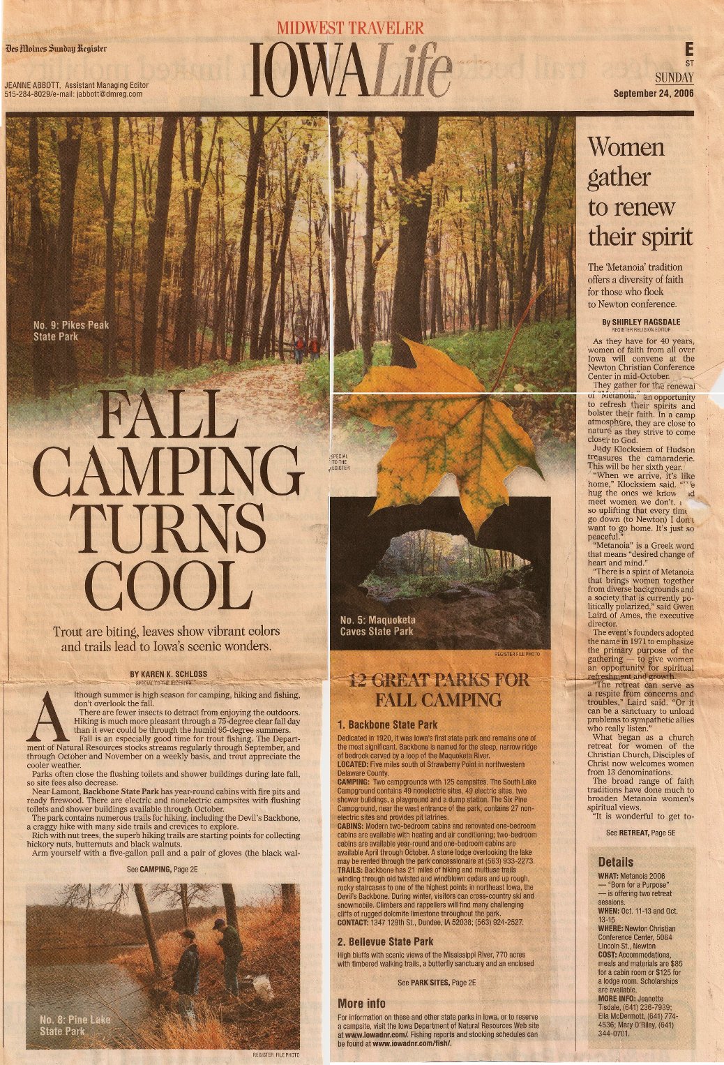
Backbone was Iowa’s first state park, and it is one of the most popular state parks. Backbone is named for its narrow and steep ridge of bedrock carved by a loop of the Maquoketa River. Backbone is a great park for hiking, and it has 21 miles of trails. Since Backbone is a popular park, it is recommended to reserve a campsite before camping. Backbone is a three hour drive from Des Moines.
Looking down at Maquoketa River from Backbone ridge
Maquoketa Caves has hilly and rocky terrain similar to Backbone, and true to its name, there are a series of caves at the park. Most of the caves require spelunking to explore, but the Dancehall Cave is so large that the hiking trail goes through it. There is also a natural rock bridge next to the Dancehall Cave. Right now, the caves are closed to help slow a disease known as white-nose syndrome that is killing bats across the eastern half of the United States. Maquoketa Caves is a 3 1/2 hour drive from Des Moines. Maquoketa Caves is a popular park for camping, and when we went, we didn’t have a reservation and found the campground was full. Luckily, we found a primitive camping area nearby at Joinerville County Park. The campground is in a small area between a road and river, so watch out for people driving by late at night. Maquoketa Caves is especially beautiful in the fall.
The Loess Hills are my favorite camping spot in Iowa. It’s the closest you will get to mountains in Iowa. The hills rise dramatically 200 feet above the flat Missouri River Valley. The Loess Hills are a unique geological formation that is only present in one other place in the world, the Yellow River in China. The Loess Hills are formed of a fine, light silt, and the hills have unique stair step terraces that form on the sides of the hills. The Loess Hills are about 2 hours and 45 minutes from Des Moines.
We usually camp at the hike-in campsites at the primitive campground at Preparation Canyon State Park. There is no water available at the trailhead, so make sure to bring enough water or a water purifier to get water from the creek. Preparation Canyon has lots of trails through the hills. In addition to the trails at Preparation Canyon, there is another great hike in Loess Hills State Forest by the Loess Hills Overlook Platform. From the overlook, you can hike along the ridges of the hills (Hike #38 in Hiking Iowa Falcon Guide). Another great hike near Pisgah is the Murray Hill Scenic Overlook.
View from Murray Hill Overlook
The last time we went to Loess Hills, we went to the Loess Hills Wildlife Management Area- Sylvan Runkel State Preserve, which is the location of the Loess Hills Prairie Seminar. We tried to follow the hike #37 in the Hiking Iowa Falcon Guide, but we had trouble finding the trail. Luckily, we ran into a couple who worked for the DNR, and they showed us this amazing unmarked trail that follows a high ridge in the hills. Primitive camping is allowed in the Loess Hills Wildlife Management Area, so we hiked up the ridge and camped on top of the ridge. To get to the “unofficial” trail, follow the directions to the Oak Avenue/178th Street parking area in the Hiking Iowa book. Drive west along 178th Street from the parking area and park at another parking area on the right. Here is a map. From the parking area, start hiking towards the ridge. You’ll hike by a field, and then you should see a faint trail that climbs up the ridge.
“The 80 acre park lies along the Cedar River in Linn County with dramatic river bluffs, deep ravines, majestic hardwood trees, wildflowers, and wildlife.”
“High bluffs with scenic views of the Mississippi River, 770 acres with timbered walking trails, a butterfly sanctuary, and an enclosed nature center are just some of the features that make this park special.”
1.85 mile trail in the Nelson Unit, and 3.9 miles out and back on trail in the Dyas Unit.
“The park was first an island sandbar in 1900. Today it encompasses 544 acres of secluded parkland where deer, geese, and eagles are abundant.” Five miles of hiking trails.
Located 11 miles from Missouri Valley and 25 miles from Council Bluffs.
This weekend is the grand opening of the new High Trestle Trail from Ankeny to Woodward, and we took a sneak peak by riding along the trail last weekend. The trail was an old railway track that was decommissioned. The trail has been in the works for 8 years, and the highlight of the trail is its namesake, the High Trestle Bridge. The bridge is 1/2 mile long and 13 stories high, and it has an amazing view of the Des Moines River!
Here is a cool video by the City of Ankeny of riding along the High Trestle Trail
(the best part is riding across the bridge at 1:28):
Jonathan and I had never put pennies on train tracks, so we decided to go try it out last weekend. We placed several different coins on the train tracks going through Water Works Park in Des Moines. Unfortunately, the trains do not come by very frequently, so we were not able to see the train run over the coins. We returned the next day, and none of the coins were still on the tracks! We looked all over, and then we spotted one of our coins! We managed to find all our coins, and every coin had been run over by the train! It rained the night before, so we think the rain may have knocked the coins off the tracks.
These are the pennies we put on the tracks, and they were completely flattened.
The coin on the left is a nickel, and the coin on the right is a quarter. Both coins were also completely flattened.
We placed a couple other coins at another spot along the tracks just beyond a bridge. These coins were still somewhat recognizable as coins and did not seem to have been hit with as much force as the other coins. We think this may have been because the train slowed down for the bridge, but we’re not sure exactly why these coins turned out differently. The smooth side of the coin was the side that was set face up on the tracks. The other side was rough with some bumps on it.
Last year, I started working on a start-up, SavvyGoose.com, and we launched the site last week! Each weekday, SavvyGoose gives away an awesome prize and also offers the prize a discount. Check it out, and sign up to win a prize! Unfortunately, according the contest rules, immediate family members are not allowed to enter the sweepstakes. 🙁 But, you can still buy the prize at a discount.
We spent an amazing week in the Galapagos, and we had a fun time hanging out with the wildlife. The animals are not afraid of people so you can go right up to them. On San Cristobal island, sea lions were everywhere! While walking in town, there was a sea lion walking down the street! The sea lions also would sleep on the benches in the parks.
San Cristobal Island
Sea lion walking down the street!
We really enjoyed watching the giant tortoises. It was especially fun to watch them eating. They don’t have any teeth, so they’re not very efficient at eating. It takes them a while to eat their food, but since they’re tortoises, they not in any hurry.
A huge tortoise who came right up to us
All of the islands have tortoise breeding centers to repopulate the islands. Ships used to stop at the Galapagos Islands and take the tortoises for food on the ship. Tortoises can live a long time without food or water, so they were a great source of fresh meat on the ships. However, this decimated the tortoise population, and a few species went extinct. The breeding of the tortoises has been very successful, and we saw lots of cute baby tortoises. They keep them at the breeding center until they are five years old, and then they are released back to the wild. While we were on Isabela Island, we saw several baby tortoises fighting over some food, even though there was plenty of food for everyone. One tortoise in particular was being a bully and knocking all the other tortoises out the way. Another tortoise retaliated against the bully and knocked him on his back. The tortoise slowly flailed his arms and legs, but didn’t make much progess towards turning himself over. Then, the same tortoise that knocked the bully over onto his back took a “running” start and knocked him back over to the front side again. It was hilarious!
Baby tortoises fighting over food
Bully tortoise that got knocked on his back
The marine iguanas were also very cool. They were hard to spot because they blended in so well with the black lava rocks. The marine iguanas have to regulate their own body temperature, and they get very cold after swimming in the ocean to eat algae off the rocks. So, when they get out of the water after feeding, they pile on top of each for warmth. It was so funny to walk along the trail and see an enormous pile of marine iguanas.
Marine iguana on Isabela Island- they are the biggest on Isabella because food is so plentiful
We had an amazing time in the Galapagos, and it was hard to leave. Our hotel on Isabela Island was right on a beautiful white sand beach, and it was a little slice of paradise. Staying at such a lovely place for our last couple nights made it even harder to leave.
We spent four days in the rain forest at Cabañas Aliñahui, the Butterfly Lodge. I went there with my parents when they came to visit me when I was done with my study abroad program in 2003. I had such a wonderful time that I returned with Jonathan and his mom.
Our cabin
The Butterfly Lodge lived up to its name. We saw lots of butterflies. The most beautiful butterflies were the brilliant blue morpho butterflies. However, they were impossible to photograph because you could only see the brilliant blue side of their wings while they’re in flight. We have lots of photos of blue blurs, but we did manage to get a few good photos. Check out the rest of our photos of butterflies.
Morpho butterfly
There are tons of insects in the rain forest, and they all seem to be super-sized. We saw huge ants called Conga ants that have huge jaws, and if you are bitten by one, you will get a fever.
Conga ant
We also saw tons of spiders. The craziest spider we saw was the poison water spider. It was the biggest spider that I have ever seen apart from a tarantula. If you get bitten, it will leave a huge hole that won’t heal for six months. Very nasty. They hide under the logs in the creeks, and they’ve very hard to spot since they blend in with the log. I was very glad that I was wearing thick rubber boots while hiking through the rain forest.
Poison water spider
Hiking through the rain forest in our stylish rubber boots
Cabañas Aliñahui had a pool table, and we tried to play pool one night. This turned out to be a disaster. We had to turn on the light, and all the bugs came out. We tried playing anyway, and then I was trying to the get the ball in the hole only to discover an enormous grasshopper was in the hole. We gave up after this. Check out the rest of our photos of the insects in the rain forest.
Enormous grasshopper!
Cabañas Aliñahui is right on the Napo River, which is one of the main tributaries of the Amazon River. Since I was at Cabañas Aliñahui last, the meander of the Napo River that went by the lodge was cut off, so it was further to get to the river.
View of Napo River from lodge
We spent a day traveling along the Napo River. We visited a family at an indigenous community and helped make chicha beer from yucca.
Mashing up yucca to make chicha
We also visited a museum about the indigenous people that live in the area. Our guide painted our faces like the indigenous do in their ceremonies. Then, we also go to try out the blowgun, which was lots of fun.
Us with our painted faces on the boat
Cassie with a blowgun!
We also visited an animal rescue center called amaZOOnico. They help to rehabilitate animals that have been illegally kept as pets and release them back into the wild. It was difficult to see animals when walking through the rain forest, so it was neat to be able to see the animals close up.
Squirrel monkey at amaZOOnico
We really enjoyed our time at Cabañas Aliñahui. Check out the rest of our photos. Unfortunately, we’re probably going to be one of the last people to visit. The government of Ecuador decided to build an huge airport right next to Cabañas Aliñahui. No one is going to want to go a lodge in the rain forest if jets are flying over all the time. So, it looks like Cabañas Aliñahui is going to be closing down before the airport opens next year. It made our visit even more special knowing that we would one of the last people to enjoy the beautiful setting of Cabañas Aliñahui.
On Thursday, Sept. 30th, we were planning to return to Quito to meet Deborah at the airport since she was flying in to join us. We were about to leave Yunguilla when we heard that the police were on strike and the airport was closed. We had no idea whether Deborah was still on her way or not, so we decided to try to return to Quito. As we were waiting for a car to take us to Calacali, a group of people returned to Yunguilla from a trip to Quito. They said it was totally crazy and dangerous in Quito, and they didn’t recommend us returning to Quito. It is dangerous in Quito with the police working, so it was total chaos with the police on strike. The police even encouraged the criminals to wreak havoc and commit as many crimes as possible while no police were on the streets. The criminals responded by robbing a bunch of banks and supermarkets. So, we decided to stay in Yunguilla until the situation settled down. We checked our email, but we didn’t hear anything from Deborah. We were able to find out more about the situation in Quito, which was totally crazy. The police went on strike because a law was passed that took away their bonuses when they were promoted and limited their salary increases. The president went down to the police barracks to try to negotiate with the police, but it became very confrontational. The president tore open his shirt while he said: “If you want to kill the president, here he is. Kill him, if you want to. Kill him if you are brave enough.” At this point, the police attacked the president with tear gas and beat him up, but the president was able to get away and took refuge in the police hospital. Later, the president claimed that he was being held against his will in the hospital, and the police had kidnapped him. Then, the military stormed the hospital and rescued the president after a shootout with the police. Doesn’t this sound like it was straight out of a Hollywood movie? Here is a good article by the BBC explaining what happened: http://www.bbc.co.uk/news/world-latin-america-11455665
The next morning, we tried to find out what was going on and whether it was safe to return to Quito. It seemed that everything had calmed down. The president was back in the presidential palace, and the military had taken control of the country in place of the police. We finally heard from Deborah. She had flown from Chicago to Atlanta, but then her flight to Quito was canceled because of the civil unrest. Of all the days to try to fly to Quito! So, she was stranded in Atlanta. She was confirmed on a flight on Tuesday, but that would be after we were supposed to go to the Galapagos. She was trying to get on the next flight to Quito on standby. Fortunately, the airport had reopened, so flights were coming into Quito again. We decided to stay in Yunguilla one more day to wait for everything to calm down more.
Saturday, we returned to Quito, and everything was completely normal. It was like nothing even happened. When we arrived, we were able to check our email again, and we found out that Deborah had made it on a flight to Quito the day before. Despite all the craziness, everything worked out okay, and we would still be able to leave for the Galapagos the next day.
We walked around the city a bit after meeting Deborah, and then, we discovered that everything was not quite back to normal. While we were walking, a bunch of armored humvees with huge guns on top drove down the street. It felt like we were in the middle of Bagdad. Then, we walked by the Presidential Palace, and there were 300 military men guarding the palace. All the streets to the presidential palace were blocked off. However, nothing was going on, and most of the activity was tourists like us taking our photo with all the military men.


